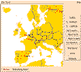
The Paradise front end allows you to display objects with spatial attributes on a 2-D map. The map provides a layered display for overlapping spatial attributes. Each layer corresponds to one query. You can customize the ordering and display of the layers by selecting color, labelling, and other display attributes for each query.
The database can be queried either with a graphical interface or with ad-hoc queries. The graphical interface can be be used to issue implicit spatial queries by zooming, clicking, and sketching a rubber-banded box. For ad-hoc queries, Paradise provides a query composer. Menus in the query composer provide access to the database schema to assist in query composition. Query results can either be viewed on the 2-D map, if they have spatial attributes, or they can be displayed in a table so that you can browse the tuples in the result. The front end also provides context-sensitive help.
Paradise supports a subset of SQL for issuing ad-hoc queries. To SQL we have added the ability to invoke methods defined on the extended set of types. For example, you can calculate the area of a polygon by using the method polygon.area(). Paradise also supports the standard database operations including create and drop database, create and drop extent, create and drop indices, insert, and update.
The current version of Paradise employs a client-server architecture. The front-end ships queries in our SQL syntax to the Paradise server for execution. After executing the query, the server ships the result objects back to the client. The Paradise server is multi-threaded so that multiple clients can connect to the same server. In designing and implementing the Paradise sever, careful attention was paid to insure that the system could efficiently process queries (especially those involving spatial attributes) on large volumes of data.

Paradise Project
ATTN: Prof. David J. DeWitt
University of Wisconsin-Madison
Computer Sciences Department
1210 West Dayton Street
Madison, WI 53706
E-mail: paradise@cs.wisc.edu